


Descrição do Horizon Explorer AR
Point your camera at a landmark you can see on the horizon (eg. Hill, Mountain, Road, Lake, Building) and see:
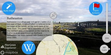
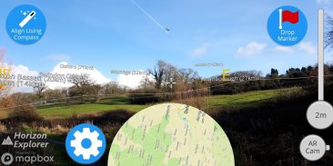
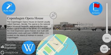
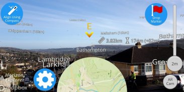
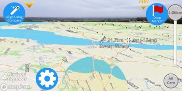
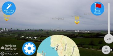
- Name of the landmark
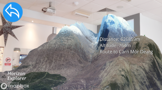
- Distance from you
- Altitude (& relative to you)
- Map of surrounding area
- Nearby towns and cities
- Wikipedia info for any landmark with a Wikipedia page
- Direction from you (eg. Northwest)
- Directions to landmark (opens in google maps)
- Street view for where you're pointing (opens in google maps)
Or use 3D Map mode:
- See terrain laid out in front of you
- Move phone to fly around the map
- Roadmap / satellite / hybrid
- Search & display 3D-maps for anywhere worldwide
- Distance, altitude and landmark names
- Infinite scroll
Horizon Explorer works worldwide, but works best on top of a hill with an unobstructed view of your surroundings. You can drag the horizon line with your finger to line up with the camera if the automatic tracking is not working very well. Or try waving your phone around in the air in a figure 8, then pressing "align using compass" to calibrate the compass.
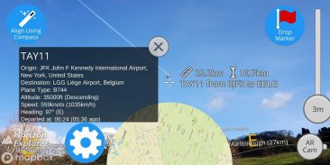
Live airplanes can also be enabled, starting from $0.99. Point at a plane and see the flight number, origin, destination, altitude and current airspeed of any commercial airline plane you can see.
If you are in a tall building, or otherwise not standing on the ground, enable "Tall Building mode" and optionally set your altitude using the slider.
Horizon Explorer will show mountain names, lakes or forests, the names & designations of roads, and many buildings.
Wikipedia Information will be displayed for anything that has an English Wikipedia article with a location set.
This app uses Google's ARCore to do augmented reality. This technology is currently available on ~50 phones: https://developers.google.com/ar/discover/supported-devices
If you don't already have the latest ARCore app installed, you will be prompted to install / update it from the Play Store when you first open Horizon Explorer.
Aponte sua câmera para um ponto de referência que você possa ver no horizonte (por exemplo, Morro, Montanha, Estrada, Lago, Edifício) e veja:
- Nome do marco
- Distância de você
- Altitude (e relativo a você)
- Mapa da área circundante
- Cidades e vilas próximas
- Informação da Wikipedia para qualquer marco com uma página da Wikipedia
- Direção sua (por exemplo, Northwest)
- Como chegar ao ponto de referência (abre no google maps)
- Street view para onde você está apontando (abre no google maps)
Ou use o modo 3D Map:
- Veja o terreno exposto à sua frente
- Mova o telefone para voar pelo mapa
- Roteiro / satélite / híbrido
- Pesquise e exiba mapas 3D para qualquer lugar do mundo
- Distância, altitude e nomes de referência
- Rolagem infinita
O Horizon Explorer funciona em todo o mundo, mas funciona melhor no topo de uma colina com uma visão desobstruída dos arredores. Você pode arrastar a linha do horizonte com o dedo para alinhar-se com a câmera se o rastreamento automático não estiver funcionando muito bem. Ou tente agitar seu telefone no ar em uma figura 8 e, em seguida, pressione "alinhe usando a bússola" para calibrar a bússola.
Aviões ao vivo também podem ser ativados, a partir de US $ 0,99. Aponte para um avião e veja o número do voo, origem, destino, altitude e velocidade atual de qualquer avião comercial que você possa ver.
Se você estiver em um edifício alto, ou não estiver de pé no chão, ative o "Modo Alto Edifício" e, opcionalmente, defina sua altitude usando o controle deslizante.
O Horizon Explorer mostrará nomes de montanhas, lagos ou florestas, os nomes e designações de estradas e muitos edifícios.
As informações da Wikipédia serão exibidas para qualquer coisa que tenha um artigo da Wikipédia em inglês com um conjunto de locais.
Este aplicativo usa o ARCore do Google para fazer realidade aumentada. Atualmente, esta tecnologia está disponível em ~ 50 telefones: https://developers.google.com/ar/discover/supported-devices
Se você ainda não tem o aplicativo ARCore mais recente instalado, será solicitado a instalá-lo / atualizá-lo na Play Store quando abrir o Horizon Explorer pela primeira vez.
Horizon Explorer AR - Versão 1.23.0
(23-04-2020)Horizon Explorer AR - Informações do APK
Versão do APK: 1.23.0Pacote: com.arrowsd.horizonexplorerApps na mesma categoria
Você também poderá gostar...


